Mafraq Governorate
Mafraq Governorate stretches from farmland on the edge of the northern highlands across the vast eastern desert. Much of its land is covered with black basalt, which gives the landscape a striking dark colour. Its ancient towns, desert forts and wide horizons show a very different side of Jordan.
The black desert
Mafraq is one of the largest governorates by area, and most of it belongs to the Badia. In the west, near the city of Mafraq, the land is a gently rolling plain where grain and vegetables are grown. Further east lies the Harrat al-Sham, a great basalt field formed by ancient volcanic eruptions, where black stones cover the ground as far as the eye can see. In the far east, seasonal pools and dry riverbeds, called wadis, collect the rare winter rain and attract wildlife and migrating birds.
Mafraq city and its towns
The name Mafraq means crossroads, and the city grew where routes to the north, the east and the desert met. In the early twentieth century it became a station on the Hejaz Railway, which linked Damascus with Medina. Today it is a regional centre of markets and services and home to Al al-Bayt University. Around the city lie farming towns and villages, many with houses and field walls built partly from the local black stone. Further east, small settlements are spread out along the long desert highway.
Basalt towns and ancient churches
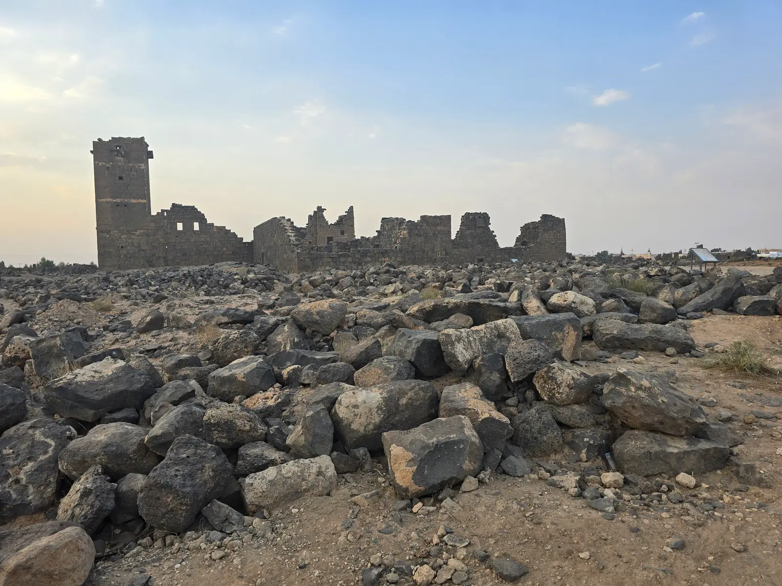
The governorate's best-known site is Umm al-Jimal, a town built almost entirely of black basalt, whose houses, churches and water reservoirs still stand to an impressive height. It was lived in from Roman times through the Byzantine and early Islamic periods, and it was added to the UNESCO World Heritage List in 2024. The village of Rihab, west of Mafraq, has the remains of many Byzantine churches with mosaic floors. Deep in the desert, Qasr Burqu', an early fort enlarged in the Umayyad period, stands beside a seasonal lake, and Jawa preserves one of the oldest towns in the region.
Nature and desert landscapes
The Burqu' area in the far north-east is a protected landscape where a desert lake, filled by winter floods, attracts water birds and supports rare plants. Foxes, hares and many kinds of lizard live in the surrounding desert. Closer to Mafraq, the plains turn green for a short time after winter rain, and in early spring they are dotted with small wildflowers. The open skies and dark nights of the eastern desert also make it an excellent place to look at the stars. Because distances are long and services are few, trips deep into the desert are best made with an experienced local guide.
Daily life, herding and food
Farming and herding remain important across the governorate. Sheep and goats graze on the plains, and their milk is turned into yoghurt, cheese, ghee and jameed, the dried yoghurt used in mansaf. In recent decades, groundwater has allowed olive groves and vegetable farms to spread across parts of the desert edge. Bedouin hospitality is central to local life: guests are welcomed with bitter Arabic coffee and are often invited to share a meal. Markets in Mafraq city sell local dairy products, grain and fresh produce from the surrounding farms.
Highlights
- 1Umm al-Jimal, the black basalt town
- 2The Byzantine churches of Rihab
- 3Qasr Burqu' and its desert lake
- 4The basalt fields of the Harrat al-Sham
- 5The ancient town of Jawa
- 6Starry skies over the eastern desert
Frequently asked questions
What is Umm al-Jimal?
Umm al-Jimal is an ancient town in northern Jordan built almost entirely of black basalt. Its houses, churches, reservoirs and other buildings were used from Roman times through the Byzantine and early Islamic periods, and many walls still stand two or three storeys high. It shows how a rural community lived and managed scarce water in the desert, and it became a UNESCO World Heritage Site in 2024.
How do I get to Umm al-Jimal from Amman?
Umm al-Jimal lies about 85 kilometres north-east of Amman, roughly one hour and fifteen minutes by car through Zarqa and Mafraq. Public transport is limited, so a rental car or a hired driver is the most practical option. The visit can be combined with the churches of Rihab or, on a longer day, with Jerash.
What does the name Mafraq mean?
Mafraq means crossroads in Arabic. The city grew at a meeting point of routes heading north, east and into the desert, and it later became a station on the Hejaz Railway. Its position still makes it a regional centre for the farming towns and desert communities of north-eastern Jordan.
Is the eastern desert of Jordan worth visiting?
Yes, for travellers who enjoy quiet landscapes and history away from the main routes. The black basalt plains, ancient towns such as Umm al-Jimal and remote sites such as Qasr Burqu' feel very different from the sandstone deserts of the south. Visit between October and April, travel with water and a full fuel tank, and use a local guide for remote areas.
Other governorates
Jerash Governorate
Ajloun Governorate
Madaba Governorate
Karak Governorate
Tafilah Governorate
Ma'an Governorate
Aqaba Governorate